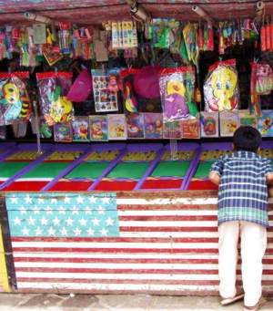
introduction geography people government economy
communications transportation transnational issues
Unlike most Guatemalans, Americans tend to enjoy measuring, correlating, categorizing and listing things in order. As an American, I'm no exception; but I have lived in Guatemala long enough to have learned that order can be more trouble than it's worth. Why anyone would care that Guatemala has 270 airports with unpaved runways less 914 meters long is beyond me; but if you do, there you are.
This came from the U.S. CIA's The World Factsbook's page on Guatemala. As such it is in the "Public Domain" and not subject to copyright restrictions. Students (and number freaks) are encouraged to use this information as they please.
- Introduction top
-
- The Mayan civilization flourished in Guatemala and surrounding regions during the first millennium A.D. After almost three centuries as a Spanish colony, Guatemala won its independence in 1821. During the second half of the 20th century, it experienced a variety of military and civilian governments, as well as a 36-year guerrilla war. In 1996, the government signed a peace agreement formally ending the conflict, which had left more than 100,000 people dead and had created, by some estimates, some 1 million refugees.
- Geography top
-
- Location: Central America, bordering the North Pacific Ocean, between El Salvador and Mexico, and bordering the Gulf of Honduras (Caribbean Sea) between Honduras and Belize
- Geographic coordinates: 15 30 N, 90 15 W
- Map references: Central America and the Caribbean
- Area: total: 108,890 sq km
land: 108,430 sq km
water: 460 sq km - Area - comparative: slightly smaller than Tennessee
- Land boundaries: total: 1,687 km
border countries: Belize 266 km, El Salvador 203 km, Honduras 256 km, Mexico 962 km - Coastline: 400 km
- Maritime claims: territorial sea: 12 nm
exclusive economic zone: 200 nm
continental shelf: 200 m depth or to the depth of exploitation - Climate: tropical; hot, humid in lowlands; cooler in highlands
- Terrain: mostly mountains with narrow coastal plains and rolling limestone plateau
- Elevation extremes: lowest point: Pacific Ocean 0 m
highest point: Volcan Tajumulco 4,211 m - Natural resources: petroleum, nickel, rare woods, fish, chicle, hydro power
- Land use: arable land: 13.22%
permanent crops: 5.6%
other: 81.18% (2005) - Irrigated land: 1,300 sq km (2003)
- Total renewable water resources: 111.3 cu km (2000)
- Freshwater withdrawal (domestic/industrial/agricultural): total: 2.01 cu km/yr (6%/13%/80%)
per capita: 160 cu m/yr (2000) - Natural hazards: numerous volcanoes in mountains, with occasional violent earthquakes; Caribbean coast extremely susceptible to hurricanes and other tropical storms
- Environment - current issues: deforestation in the Peten rain forest; soil erosion; water pollution
- Environment - international agreements: party to: Antarctic Treaty, Biodiversity, Climate Change, Climate Change-Kyoto Protocol, Desertification, Endangered Species, Environmental Modification, Hazardous Wastes, Law of the Sea, Marine Dumping, Ozone Layer Protection, Ship Pollution, Wetlands, Whaling
signed, but not ratified: none of the selected agreements - Geography - note: no natural harbors on west coast
- People top
-
- Population: 13,276,517 (July 2009 est.)
- Age structure: 0-14 years: 39.4% (male 2,664,058/female 2,573,006)
15-64 years: 56.8% (male 3,655,184/female 3,884,331)
65 years and over: 3.8% (male 231,652/female 268,286) (2009 est.) - Median age: total: 19.4 years
male: 18.9 years
female: 20 years (2009 est.) - Population growth rate: 2.066% (2009 est.)
- Birth rate: 27.98 births/1,000 population (2009 est.)
- Death rate: 5.19 deaths/1,000 population (2008 est.)
- Net migration rate: -2.21 migrant(s)/1,000 population (2009 est.)
- Urbanization: urban population: 49% of total population (2008)
rate of urbanization: 3.4% annual rate of change (2005-10 est.) - Sex ratio: at birth: 1.05 male(s)/female
under 15 years: 1.03 male(s)/female
15-64 years: 0.94 male(s)/female
65 years and over: 0.86 male(s)/female
total population: 0.97 male(s)/female (2009 est.) - Infant mortality rate: total: 27.84 deaths/1,000 live births
male: 30.2 deaths/1,000 live births
female: 25.35 deaths/1,000 live births (2009 est.) - Life expectancy at birth: total population: 70.29 years
male: 68.49 years
female: 72.19 years (2009 est.) - Total fertility rate: 3.47 children born/woman (2009 est.)
- HIV/AIDS - adult prevalence rate: 0.8% (2007 est.)
- HIV/AIDS - people living with HIV/AIDS: 59,000 (2007 est.)
- HIV/AIDS - deaths: 3,900 (2007 est.)
- Major infectious diseases: degree of risk: high
food or waterborne diseases: bacterial diarrhea, hepatitis A, and typhoid fever
vector borne disease: dengue fever and malaria
water contact disease: leptospirosis (2009) - Nationality: noun: Guatemalan(s)
adjective: Guatemalan  Ethnic groups: Mestizo (mixed Amerindian-Spanish - in local Spanish called Ladino) and European 59.4%, K'iche 9.1%, Kaqchikel 8.4%, Mam 7.9%, Q'eqchi 6.3%, other Mayan 8.6%, indigenous non-Mayan 0.2%, other 0.1% (2001 census)
- Religions: Roman Catholic, Protestant, indigenous Mayan beliefs
- Languages: Spanish 60%, Amerindian languages 40% (23 officially recognized Amerindian languages, including Quiche, Cakchiquel, Kekchi, Mam, Garifuna, and Xinca)
- Literacy: definition: age 15 and over can read and write
total population: 69.1%
male: 75.4%
female: 63.3% (2002 census) - School life expectancy (primary to tertiary education): total: 10 years
male: 11 years
female: 10 years (2006) - Education expenditures: 2.6% of GDP (2006)
- Government top
-
- Country name: conventional long form: Republic of Guatemala
conventional short form: Guatemala
local long form: Republica de Guatemala
local short form: Guatemala - Government type: constitutional democratic republic
- Capital: name: Guatemala
geographic coordinates: 14 37 N, 90 31 W
time difference: UTC-6 (1 hour behind Washington, DC during Standard Time)
daylight saving time: +1hr, begins last Sunday in April; ends last Friday in September; note - there is no DST planned for 2007-2009 - Administrative divisions: 22 departments (departamentos, singular - departamento); Alta Verapaz, Baja Verapaz, Chimaltenango, Chiquimula, El Progreso, Escuintla, Guatemala, Huehuetenango, Izabal, Jalapa, Jutiapa, Peten, Quetzaltenango, Quiche, Retalhuleu, Sacatepequez, San Marcos, Santa Rosa, Solola, Suchitepequez, Totonicapan, Zacapa
- Independence: 15 September 1821 (from Spain)
- National holiday: Independence Day, 15 September (1821)
- Constitution: 31 May 1985, effective 14 January 1986; suspended 25 May 1993; reinstated 5 June 1993; amended November 1993
- Legal system: civil law system; judicial review of legislative acts; has not accepted compulsory ICJ jurisdiction
- Suffrage: 18 years of age; universal; note - active duty members of the armed forces may not vote and are restricted to their barracks on election day
- Executive branch: chief of state: President Alvaro COLOM Caballeros (since 14 January 2008); Vice President Jose Rafael ESPADA (since 14 January 2008); note - the president is both the chief of state and head of government
head of government: President Alvaro COLOM Caballeros (since 14 January 2008); Vice President Jose Rafael ESPADA (since 14 January 2008)
cabinet: Council of Ministers appointed by the president
elections: president elected by popular vote for a four-year term (may not serve consecutive terms); election last held 9 September 2007; runoff held 4 November 2007 (next to be held September 2011)
election results: Alvaro COLOM Caballeros elected president; percent of vote - Alvaro COLOM Caballeros 52.8%, Otto PEREZ Molina 47.2% - Legislative branch: unicameral Congress of the Republic or Congreso de la Republica (158 seats; members are elected by popular vote to serve four-year terms)
elections: last held 9 September 2007 (next to be held in September 2011)
election results: percent of vote by party - UNE 30.4%, GANA 23.4%, PP 18.9%, FRG 9.5%, PU 5.1%, other 12.7%; seats by party - UNE 48, GANA 37, PP 30, FRG 15, PU 8, CASA 5, EG 4, PAN 4, UCN 4, URNG 2, UD 1 - Judicial branch: Constitutional Court or Corte de Constitucionalidad is Guatemala's highest court (five judges are elected for concurrent five-year terms); Supreme Court of Justice or Corte Suprema de Justicia (13 members serve concurrent five-year terms and elect a president of the Court each year from among their number; the president of the Supreme Court of Justice also supervises trial judges around the country, who are named to five-year terms)
- Political parties and leaders: Center of Social Action or CASA [Eduardo SUGER]; Democracy Front or FRENTE [Alfonso CABRERA]; Democratic Union or UD [Manuel CONDE Orellana]; Encounter for Guatemala or EG [Nineth MONTENGRO]; Grand National Alliance or GANA [Alfredo VILLA]; Guatemalan National Revolutionary Unity or URNG [Hector NUILA]; Guatemalan Republican Front or FRG [Efrain RIOS Montt]; National Advancement Party or PAN [Juan Guillermo GUTIERREZ]; National Unity for Hope or UNE [Juan Jose ALFARO Lemus]; Nationalist Change Union or UCN [Mario ESTRADA]; Patriot Party or PP [Ret. Gen. Otto PEREZ Molina]; Unionista Party or PU [Fritz GARCIA-GALLONT]
- Political pressure groups and leaders: Agrarian Owners Group or UNAGRO; Alliance Against Impunity or AAI; Committee for Campesino Unity or CUC; Coordinating Committee of Agricultural, Commercial, Industrial, and Financial Associations or CACIF; Mutual Support Group or GAM
- International organization participation: BCIE, CACM, FAO, G-24, G-77, IADB, IAEA, IBRD, ICAO, ICC, ICRM, IDA, IFAD, IFC, IFRCS, IHO, ILO, IMF, IMO, Interpol, IOC, IOM, IPU, ISO (correspondent), ITSO, ITU, ITUC, LAES, LAIA (observer), MIGA, MINUSTAH, MONUC, NAM, OAS, OPANAL, OPCW, PCA, RG, UN, UNCTAD, UNESCO, UNIDO, UNIFIL, Union Latina, UNMIS, UNOCI, UNWTO, UPU, WCL, WCO, WFTU, WHO, WIPO, WMO, WTO
- Diplomatic representation in the US: chief of mission: Ambassador Francisco VILLAGRAN de Leon
chancery: 2220 R Street NW, Washington, DC 20008
telephone: [1] (202) 745-4952
FAX: [1] (202) 745-1908
consulate(s) general: Chicago, Denver, Houston, Los Angeles, Miami, New York, Providence, San Francisco - Diplomatic representation from the US: chief of mission: Ambassador Stephen G. MCFARLAND
embassy: 7-01 Avenida Reforma, Zone 10, Guatemala City
mailing address: APO AA 34024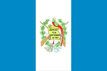 telephone: [502] 2326-4000
FAX: [502] 2326-4654 - Flag description: three equal vertical bands of light blue (hoist side), white, and light blue, with the coat of arms centered in the white band; the coat of arms includes a green and red quetzal (the national bird) and a scroll bearing the inscription LIBERTAD 15 DE SEPTIEMBRE DE 1821 (the original date of independence from Spain) all superimposed on a pair of crossed rifles and a pair of crossed swords and framed by a wreath
- Country name: conventional long form: Republic of Guatemala
- Economy top
-
- Economy - overview: Guatemala is the most populous of the Central American countries with a GDP per capita roughly one-half that of Argentina, Brazil, and Chile. The agricultural sector accounts for about one-tenth of GDP, two-fifths of exports, and half of the labor force. Coffee, sugar, and bananas are the main products, with sugar exports benefiting from increased global demand for ethanol. The 1996 signing of peace accords, which ended 36 years of civil war, removed a major obstacle to foreign investment, and Guatemala since then has pursued important reforms and macro economic stabilization. The Central American Free Trade Agreement (CAFTA) entered into force in July 2006 and has since spurred increased investment in the export sector, but concerns over security, the lack of skilled workers and poor infrastructure continued to hamper foreign participation. The distribution of income remains highly unequal with more than half of the population below the national poverty line. Other ongoing challenges include increasing government revenues, negotiating further assistance from international donors, curtailing drug trafficking and rampant crime, and narrowing the trade deficit. Given Guatemala's large expatriate community in the United States, it is the top remittance recipient in Central America, with inflows serving as a primary source of foreign income equivalent to nearly two-thirds of exports. Economic growth will slow in 2009 as export demand from US and other Central American markets drop and foreign investment slows amid the global slowdown.
- GDP (purchasing power parity): $68.02 billion (2008 est.)
$65.53 billion (2007)
$62 billion (2006)
note: data are in 2008 US dollars - GDP (official exchange rate): $36.28 billion (2008 est.)
- GDP - real growth rate: 3.8% (2008 est.)
5.7% (2007 est.)
5.3% (2006 est.) - GDP - per capita (PPP): $5,200 (2008 est.)
$5,100 (2007 est.)
$5,000 (2006 est.)
note: data are in 2008 US dollars - GDP - composition by sector: agriculture: 13.2%
industry: 25.8%
services: 61% (2008 est.) - Labor force: 4.054 million (2008 est.)
- Labor force - by occupation: agriculture: 50%
industry: 15%
services: 35% (1999 est.) - Unemployment rate: 3.2% (2005 est.)
- Population below poverty line: 56.2% (2004 est.)
- Household income or consumption by percentage share: lowest 10%: 0.9%
highest 10%: 43.4% (2002) - Distribution of family income - Gini index: 55.1 (2007)
- Investment (gross fixed): 20.3% of GDP (2008 est.)
- Budget: revenues: $4.944 billion
expenditures: $5.647 billion (2008 est.) - Fiscal year: calendar year
- Public debt: 23.7% of GDP (2008 est.)
- Inflation rate (consumer prices): 12.2% (2008 est.)
- Central bank discount rate: NA
- Commercial bank prime lending rate: 12.84% (31 December 2007)
- Stock of money: $6.227 billion (31 December 2007)
- Stock of quasi money: $8.928 billion (31 December 2007)
- Stock of domestic credit: $13.96 billion (31 December 2007)
- Market value of publicly traded shares: $NA
- Agriculture - products: sugarcane, corn, bananas, coffee, beans, cardamom; cattle, sheep, pigs, chickens
- Industries: sugar, textiles and clothing, furniture, chemicals, petroleum, metals, rubber, tourism
- Industrial production growth rate: 3.5% (2008 est.)
- Electricity - production: 7.643 billion kWh (2006 est.)
- Electricity - consumption: 6.617 billion kWh (2006 est.)
- Electricity - exports: 131.9 million kWh (2007 est.)
- Electricity - imports: 8.11 million kWh (2007 est.)
- Electricity - production by source: fossil fuel: 51.9%
hydro: 35.2%
nuclear: 0%
other: 12.9% (2001) - Oil - production: 15,820 bbl/day (2007 est.)
- Oil - consumption: 74,230 bbl/day (2006 est.)
- Oil - exports: 15,560 bbl/day (2006 est.)
- Oil - imports: 72,960 bbl/day (2006 est.)
- Oil - proved reserves: 83.07 million bbl (1 January 2008 est.)
- Natural gas - production: 0 cu m (2007 est.)
- Natural gas - consumption: 0 cu m (2007 est.)
- Natural gas - exports: 0 cu m (2007 est.)
- Natural gas - imports: 0 cu m (2007 est.)
- Natural gas - proved reserves: 2.96 billion cu m (1 January 2006 est.)
- Current account balance: -$3.316 billion (2008 est.)
- Exports: $8.028 billion f.o.b. (2008 est.)
- Exports - commodities: coffee, sugar, petroleum, apparel, bananas, fruits and vegetables, cardamom
- Exports - partners: US 42.2%, El Salvador 9.6%, Honduras 8.6%, Mexico 6.5%, Costa Rica 4.5% (2007)
- Imports: $15.42 billion f.o.b. (2008 est.)
- Imports - commodities: fuels, machinery and transport equipment, construction materials, grain, fertilizers, electricity
- Imports - partners: US 34.9%, Mexico 9.9%, China 6.8%, El Salvador 4.6%, Costa Rica 4.1% (2007)
- Reserves of foreign exchange and gold: $4.229 billion (31 December 2008 est.)
- Debt - external: $6.337 billion (31 December 2008 est.)
- Currency (code): quetzal (GTQ), US dollar (USD), others allowed
- Currency code: GTQ; USD
- Exchange rates: quetzales (GTQ) per US dollar - 7.5895 (2008 est.), 7.6833 (2007), 7.6026 (2006), 7.6339 (2005), 7.9465 (2004)
- Communications top
-
- Telephones - main lines in use: 1.355 million (2006)
- Telephones - mobile cellular: 10.15 million (2007)
- Telephone system: general assessment: fairly modern network centered in the city of Guatemala
domestic: state-owned telecommunications company privatized in the late 1990s opening the way for competition; fixed-line teledensity 11 per 100 persons; fixed-line investments are being concentrated on improving rural connectivity; mobile-cellular teledensity 80 per 100 persons
international: country code - 502; landing point for both the Americas Region Caribbean Ring System (ARCOS-1) and the SAM-1 fiber optic submarine cable system that together provide connectivity to South and Central America, parts of the Caribbean, and the US; connected to Central American Microwave System; satellite earth station - 1 Intelsat (Atlantic Ocean) - Radio broadcast stations: AM 130, FM 487, short wave 15 (2000)
- Radios: 835,000 (1997)
- Television broadcast stations: 26 (plus 27 repeaters) (1997)
- Televisions: 1.323 million (1997)
- Internet country code: .gt
- Internet hosts: 124,095 (2008)
- Internet Service Providers (ISPs): 5 (2000)
- Internet users: 1.32 million (2006)
- Transportation top
-
- Airports: 374 (2008)
- Airports - with paved runways: total: 12
2,438 to 3,047 m: 3
1,524 to 2,437 m: 2
914 to 1,523 m: 4
under 914 m: 3 (2008) - Airports - with unpaved runways: total: 362
2,438 to 3,047 m: 1
1,524 to 2,437 m: 5
914 to 1,523 m: 86
under 914 m: 270 (2008) - Pipelines: oil 480 km (2008)
- Railways: total: 886 km
narrow gauge: 886 km 0.914-m gauge (2006) - Roadways: total: 14,095 km
paved: 4,863 km (includes 75 km of expressways)
unpaved: 9,232 km (2000) - Waterways: 990 km
note: 260 km navigable year round; additional 730 km navigable during high-water season (2007) - Ports and terminals: Puerto Quetzal, Santo Tomas de Castilla
- Transnational Issues top
-
- Disputes - international: annual ministerial meetings under the OAS-initiated Agreement on the Framework for Negotiations and Confidence Building Measures continue to address Guatemalan land and maritime claims in Belize and the Caribbean Sea; the Line of Adjacency created under the 2002 Differendum serves in lieu of the contiguous international boundary to control squatting in the sparsely inhabited rain forests of Belize's border region; Mexico must deal with thousands of impoverished Guatemalans and other Central Americans who cross the porous border looking for work in Mexico and the United States
- Refugees and internally displaced persons: IDPs: undetermined (the UN does not estimate there are any IDPs, although some NGOs estimate over 200,000 IDPs as a result of over three decades of internal conflict that ended in 1996) (2007)
- Trafficking in persons: current situation: Guatemala is a source, transit, and destination country for Guatemalans and Central Americans trafficked for the purposes of commercial sexual exploitation and forced labor; human trafficking is a significant and growing problem in the country; Guatemalan women and children are trafficked within the country for commercial sexual exploitation, primarily to Mexico and the United States; Guatemalan men, women, and children are also trafficked within the country, and to Mexico and the United States, for forced labor
tier rating: Tier 2 Watch List - for a second consecutive year, Guatemala is on the Tier 2 Watch List for its failure to provide evidence of increasing efforts to combat trafficking in persons, particularly with respect to ensuring that trafficking offenders are appropriately prosecuted for their crimes; while prosecutors initiated trafficking prosecutions, they continued to face problems in court with application of Guatemala's comprehensive anti-trafficking law; the government made modest improvements to its protection efforts, but assistance remained inadequate overall in 2007 (2008) - Illicit drugs: major transit country for cocaine and heroin; in 2005, cultivated 100 hectares of opium poppy after reemerging as a potential source of opium in 2004; potential production of less than 1 metric ton of pure heroin; marijuana cultivation for mostly domestic consumption; proximity to Mexico makes Guatemala a major staging area for drugs (particularly for cocaine); money laundering is a serious problem; corruption is a major problem