The map to the right includes what the USGS (United States Geological Survey) considers to be the "Major Volcanoes of Guatemala". What their criteria for "major" is I don't know. For example it doesn't include Guatemala's two tallest volcanoes (Tajumulco - 4220 mt - 13,845 ft and Tacana 4092 mt 13,425 ft ~ both are to the left and slightly above Santa Maria); but far be it from me to question the experts. Go to josemonzongt.com's page on Guatemala volcanoes. Guatemala's volcanoes are part of the Ring of Fire that surrounds the Pacific Rim.
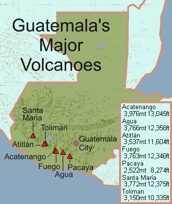
This is from the USGS's website, on their web page on Guatemalan volcanoes. That page has proper footnotes if you interested in more detailed information.
- General
- Most active volcanoes in the Mexico/Central American Region occur in belts produced by subduction of Pacific oceanic crust beneath the southern edge of the North American Plate and the western edge of the Caribbean Plate. Large stratovolcanoes and silicic calderas are found here, but the region also contains many basaltic volcanic fields, particularly in the central valley of Mexico and along the Guatemala-El Salvador border. A few other active volcanoes in northern Mexico are related to extensional tectonics of the Basin and Range Province, which split the Baja California peninsula from the mainland. ...
- The explosive eruption of Guatemala's Santa Maria volcano in 1902 was one of the world's largest 20th-century eruptions. ...
- Volcanism in Guatemala results from subduction of the Cocos plate beneath the Caribbean plate.
- Acatenango
- Acatenango, along with its twin volcano to the south, Volcan Fuego, overlooks the historic former capital city of Antigua Guatemala. Acatenango, which has two principal summits, was constructed during three eruptive periods post-dating the roughly 85,000 year old Los Chocoyos tephra from Atitlan caldera. An ancestral Acatenango volcano collapsed to the south, prior to the formation of Fuego volcano, forming the La Democracia debris-avalanche deposit, which covers a wide area of the Pacific coastal plain. Construction of Yepocapa, the northern summit of Acatenango, was completed about 20,000 years ago, after which growth of the southern and highest cone, Pico Central (also known as Pico Mayor), began. The first well-documented eruptions of Acatenango took place from 1924 to 1927, although earlier historical eruptions may have occurred. Francisco Vasquez, writing in 1690, noted that in 1661 a volcano which lay aside of Fuego "opened a smoking mouth and still gives off smoke from another three, but without noise."
- The Fuego-Acatenango massif comprises a string of five or more volcanic vents along a north-south trend that is perpendicular to that of the Central American arc in Guatemala. From north to south known centers of volcanism are Ancient Acatenango, Yepocapa, Pico Mayor de Acatenango, Meseta, and Fuego. Volcanism along the trend stretches back more than 200,000 years. Although many of the centers have been active contemporaneously, there is a general sequence of younger volcanism, from north to south along the trend.
- This massive volcano complex towers more than 3,500 meters above the Pacific coastal plain to the south and 2,000 meters above the Guatemalan Highlands to the north. The volcano complex comprises remnants of multiple eruptive centers, which periodically have collapsed to form huge debris avalanches. The largest of these avalanches extended more than 50 kilometers from its source and covered more than 300 square kilometers. The volcano has potential to produce huge debris avalanches that could inundate large areas of the Pacific coastal plain. In areas around the volcanoes and downslope toward the coastal plain,more than 100,000 people are potentially at risk from these and other flowage phenomena. ...
- The only known historical eruptions of Acatenango volcano occurred in the 20th century, between 1924 and 1927 from just north of the summit peak (Pico Mayor) and again in December 1972 from the saddle between Yepocapa and Pico Mayor. These phreatic explosions generated ballistic bombs that fell near the summit craters and fine ash that fell up to 25 kilometers away. In prehistoric time, Acatenango has erupted explosively to form widespread fall deposits, hot pyroclastic flows and lava flows. There have been numerous eruptions during the past 80,000 years from vents along the massif. The most recent explosive eruptions of Acatenango occurred 1,900 years ago (Pico Mayor), 2,300 years ago (Pico Mayor) and about 5000 years ago (Yepocapa). If such eruptions were to recur, many people and costly infrastructure would be at risk.
- Agua
- At 3,760 meters, Agua volcano towers more than 3,500 meters above the Pacific coastal plain to the south and 2,000 meters above the Guatemalan highlands to the north. The volcano is within 5 to 10 kilometers of Antigua, Guatemala and several other large towns situated on its northern apron. These towns have a combined population of nearly 100,000. It is within about 20 kilometers of Escuintla (population,ca .100,000) to the south. Though the volcano has not been active in historical time, or about the last 500 years, it has the potential to produce debris flows (watery flows of mud, rock,and debris -- also known as lahars when they occur on a volcano) that could inundate these nearby populated areas.
- Amatitlán Caldera
- Pacaya Volcano and Amatitlán Caldera lie within a north-northeast-trending graben at its intersection with an east-southeast west-northwest-trending left-lateral strike-slip fault (an extension of the Jalpatagua Fault). Pacaya and Amatitlán also lie astride the boundary between the central and eastern Guatemala segments of the Cocos-Caribbean subduction zone (Stoiber and Carr, 1973; Carr, 1976). The Amatitlán area has been identified by Koch and McLean (1975) and Wunderman and Rose (1984) as the source of several voluminous silicic tephras in central Guatemala. At least nine major pyroclastic deposits, with a total volume of more than 70 cubic kilometers (dense rock equivalent), were emplaced between about 300,000 years and 23,000 years B.P. (Wunderman and Rose, 1984). Wunderman and Rose (1984) inferred an Amatitlán Caldera with a resurgent dome. Postcaldera vents include a number of silicic domes in and around the caldera, and Pacaya Volcano, a basaltic and basaltic-andesite stratovolcano on the southern boundary of the caldera.
- Atitlán
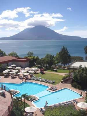 Volcanism in Guatemala results from subduction of the Cocos plate beneath the Caribbean plate. The modern Atitlan Caldera is thought to have formed at the intersection of a northeast-southwest-trending fossil boundary between the western and central Guatemala segments of Cocos-Caribbean subduction and the modern volcanic front (Newhall, 1987). Today, the principal faults of the Atitlan area are right-lateral northwest-southeast strike-slip faults, conjugate left-lateral northeast-southwest strike-slip faults, and an inferred north-south tension fracture that is defined by a north-south alignment of the modern stratovolcanoes. The modern caldera is about 35 kilometers south of the Motagua
(middle) part of the boundary between the Caribbean and North American plates.
Volcanism in Guatemala results from subduction of the Cocos plate beneath the Caribbean plate. The modern Atitlan Caldera is thought to have formed at the intersection of a northeast-southwest-trending fossil boundary between the western and central Guatemala segments of Cocos-Caribbean subduction and the modern volcanic front (Newhall, 1987). Today, the principal faults of the Atitlan area are right-lateral northwest-southeast strike-slip faults, conjugate left-lateral northeast-southwest strike-slip faults, and an inferred north-south tension fracture that is defined by a north-south alignment of the modern stratovolcanoes. The modern caldera is about 35 kilometers south of the Motagua
(middle) part of the boundary between the Caribbean and North American plates.- Three large calderas have formed in the Atitlan region in the past 14 million years (Newhall, 1987). The modern Atitlan (III) Caldera formed approximately 84,000 years ago, shortly after an eruption of about 250 cubic kilometers of rhyolitic magma (Koch and McLean, 1975; Hahn and others, 1979; Drexler and others, 1980; Rose and others, 1987; Newhall, 1987). Three postcaldera stratovolcanoes -- Vulcan San Pedro, Vulcan Toliman, and Vulcan Atitlan -- have grown on or just inside the southern boundary of the caldera (Rose and others, 1980).
- The first recorded eruption of Atitlan was in 1469 (von Seebach, 1892). The volcano "awoke" in 1717 and remained "active" until 1721 (Sapper, 1925). Other eruptions occurred ... (1469, 1717-21, 1826-28, 1833?, 1837, 1843?, 1852?-53, 1856?); the only strong eruption among these was on 3 May 1853, when ash darkened the sky around Lake Atitlan from 1100 to 1400 hours (Sapper, 1925).
- Aside from the eruptions of Vulcan Atitlan, little is known about unrest at Atitlan Caldera. Seismicity has been low during the past decade or more (White and Harlow, 1979, 1980; Harlow and White, 1980). There is a hint of relatively long-period fluctuations in lake level; the lake level was reportedly low in the 1820's, 10-15 meters higher in the 1870's, back down to its low level in the 1920's, and high again from the 1940's to the present Most fluctuation is a result of variation in annual rainfall or the effects of regional earthquakes on the subsurface drainage from the lake; it is not known whether any uplift and subsidence of the caldera floor is involved. Short-term changes in lake level that are attributable to rainfall may be as great as the increase of 3.3 meters during the exceptionally wet year of 1933; those attributable to earthquakes may be as great as the drop of 2 meters that occurred within one month following the Guatemala earthquake (magnitude=7.5) of 4 February 1976 (Newhall and others, 1987). Sediments of the lake floor suggest episodic, decades-long increases in sublacustrine thermal activity: alternating decades-long periods with and without annual lake overturn are interpreted as periods of relatively high and low activity of fumaroles on the caldera floor (Newhall and others, 1987).
- Fuego
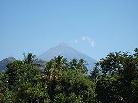 Volcan Fuego, one of Central America's most active volcanoes, is one of three large stratovolcanoes overlooking Guatemala's former capital, Antigua. The scarp of an older edifice, Meseta, lies between Fuego and its twin volcano to the north, Acatenango. Collapse of the ancestral Meseta volcano about 8500 years ago produced the massive Escuintla debris-avalanche deposit, which extends about 50 kilometers onto the Pacific coastal plain. Growth of the modern Fuego volcano followed, continuing the southward migration of volcanism that began at Acatenango. Frequent vigorous historical eruptions have been recorded since 1524, and have produced major ashfalls, along with occasional pyroclastic flows and lava flows.
- The Fuego-Acatenango massif comprises a string of five or more volcanic vents along a north-south trend that is perpendicular to that of the Central American arc in Guatemala. From north to south known centers of volcanism are Ancient Acatenango, Yepocapa, Pico Mayor de Acatenango, Meseta, and Fuego. Volcanism along the trend stretches back more than 200,000 years. Although many of the centers have been active contemporaneously, there is a general sequence of younger volcanism, from north to south along the trend.
- This massive volcano complex towers more than 3,500 meters above the Pacific coastal plain to the south and 2,000 meters above the Guatemalan Highlands to the north. The volcano complex comprises remnants of multiple eruptive centers, which periodically have collapsed to form huge debris avalanches. The largest of these avalanches extended more than 50 kilometers from its source and covered more than 300 square kilometers. The volcano has potential to produce huge debris avalanches that could inundate large areas of the Pacific coastal plain. In areas around the volcanoes and downslope toward the coastal plain,more than 100,000 people are potentially at risk from these and other flowage phenomena.
- In historical time, Fuego has erupted more than 60 times. It has spread volcanic ash to population centers such as Escuintla (population 75,000+) 20 kilometers to the south, Antigua (population 25,000) 15 kilometers to the southwest and Guatemala City (population 2.2 million), the country's capital and largest city, 40 kilometers to the southwest. The volcano commonly produces plumes of fine ash up to 10 kilometers high, lava flows, and hot pyroclastic flows. During periods of rain, volcaniclastic debris remobilizes to form volcanic debris flows (also commonly known as lahars). After periods of volcanism, channels are choked with sediment. As a result, floods spill onto adjacent interfluves, and periodically river channels change their course.
- Pacaya
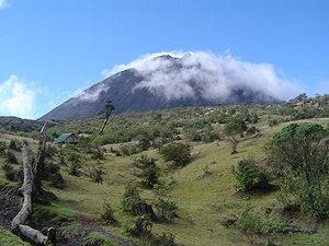 Pacaya sits 30 kilometers south of the center of Guatemala City, an urban center with a population of more than 1.5 million. A 1989 eruption produced a 4.5-kilometer-tall eruption column and enlarged the MacKenney crater. Lava flows followed in 1990-91. Strong eruptive activity in June-August 1991 destroyed part of the MacKenney cone and damaged villages to the west. Lavas have often flowed out of the collapsed south-southwest sector, traveling away from most inhabited areas. The international airport (La Aurora) lies ~23 kilometers from the crater and airplanes commonly fly over the volcano.
- Eruptions from Pacaya, one of Guatemala's most active volcanoes, are frequently visible from Guatemala City, the nation's capital. Pacaya is a complex volcano constructed on the southern rim of the 14 x 16 kilometers Pleistocene Amatitlan caldera. A cluster of dacitic lava domes occupies the caldera floor. The Pacaya massif includes the Cerro Grande lava dome and a younger volcano to the southwest. Collapse of Pacaya volcano about 1,100 years ago produced a debris-avalanche deposit that extends 25 kilometers onto the Pacific coastal plain and left an arcuate somma rim inside which the modern Pacaya volcano (MacKenney cone) grew. A subsidiary crater, Cerro Chino, was constructed on the northwest somma rim. During the past several decades, activity at Pacaya has consisted of frequent strombolian eruptions with intermittent lava flow extrusion on the flanks of MacKenney cone, punctuated by occasional larger explosive eruptions.
- Pacaya Volcano and Amatitlán Caldera lie within a north-northeast-trending graben at its intersection with an east-southeast west-northwest-trending left-lateral strike-slip fault (an extension of the Jalpatagua Fault). Pacaya and Amatitlán also lie astride the boundary between the central and eastern Guatemala segments of the Cocos-Caribbean subduction zone (Stoiber and Carr, 1973; Carr, 1976). The Amatitlán area has been identified by Koch and McLean (1975) and Wunderman and Rose (1984) as the source of several voluminous silicic tephras in central Guatemala. At least nine major pyroclastic deposits, with a total volume of more than 70 cubic kilometers (dense rock equivalent), were emplaced between about 300,000 years and 23,000 years B.P. (Wunderman and Rose, 1984). Wunderman and Rose (1984) inferred an Amatitlán Caldera with a resurgent dome. Postcaldera vents include a number of silicic domes in and around the caldera, and Pacaya Volcano, a basaltic and basaltic-andesite stratovolcano on the southern boundary of the caldera.
- Eruptions from Pacaya are frequent. Eruptions in 1565 and 1651, and perhaps since, were preceded or accompanied by strong earthquakes (Sapper, 1925). The most recent eruptions began in March 1983 and were continuing as of May 1987. Fumarolic activity from an area called Los Humitos, on Pacaya, began in 1891 and increased markedly in 1897 but eventually subsided without an eruption (Sapper, 1925, p.34).
- Santa María and Santiaguito
- One of the largest eruptions of the 20th century occurred at Santa María in 1902. The eruption left a 700 x 1,000 meter crater in the stratovolcano's southwest flank. Growth of a dacite dome called Santiaguito began in this crater in 1922. The largest pyroclastic flow since 1922 took place in 1929 and killed from hundreds to as many as 5,000 persons. During the next three eruptive pulses the active vent migrated west from a vent called Caliente to vents named La Mitad (1939-42), El Monje (1949-55), and El Bruje (1959-63).
- The symmetrical, forest-covered Santa María volcano is one of a chain of large stratovolcanoes that rises dramatically above the Pacific coastal plain of Guatemala. The stratovolcano has a sharp-topped, conical profile that is cut on the southwest flank by a large, 1-kilometer-wide crater, which formed during a catastrophic eruption in 1902 and extends from just below the summit to the lower flank. The renowned plinian eruption of 1902 followed a long repose period and devastated much of southwest Guatemala. The large dacitic Santiaguito lava-dome complex has been growing at the base of the 1902 crater since 1922. Compound dome growth at Santiaguito has occurred episodically from four westward-younging vents, accompanied by almost continuous minor explosions and periodic lava extrusion, larger explosions, pyroclastic flows, and lahars.